

One of the basic tenets of fieldcraft is being able to locate and observe both people and animals. When we do this, we don’t want to wander aimlessly about. Rather we are best served to use a combination of our knowledge of our quarry and our reading of the terrain. With those two things it is much easier to make some educated guesses, focusing on the places we initially scout makes the best use of limited time.
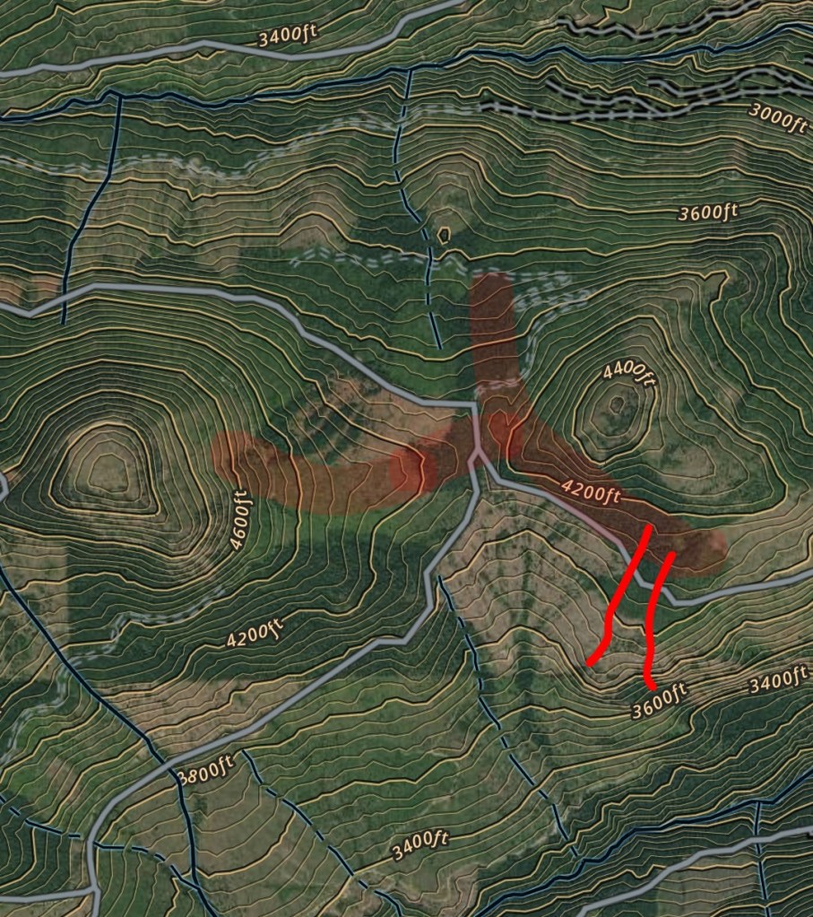
Have you ever noticed when you travel through a place, wild or urban, animals and people seem to end up taking the same sorts of paths. The natural lay of the land, the path of least resistance is another way of saying these. Possibly a path offering the most concealment from view. Natural lines of drift are routes that will likely be travelled by both people and animals.
These are important to recognize for a couple of reasons, not just for your own ease of travel. Recognizing these areas is also beneficial if you are trying to find where people or animals are passing through. Lastly if you are trying to avoid those places where people or animals are most likely to be.
Examples areas that would be more likely to be a line of drift are:
- Ridgelines – this terrain typically has sparser vegetation and in easier to navigate.
- Down the center of a valley.
- Paralleling a water way or other linear feature.
- Through saddles, also known as notches or passes.
- Inside tree lines.
- At the base of a hill.
- Places where vegetation changes.
- Clear cuts.
- Strips of concealing terrain or vegetation.
- Terrain which is easier to travel.
You need to have an idea where your quarry hangs out. People and animals are both creatures of habit. Animals specifically, but also people, have a few basic needs they are going to meet every day, and a few more which are seasonally. Every animal needs to have food, water, and a place to sleep, every single day. Seasonally they will breed, raise young, and possibly migrate. If you want to find an animal, learn how the species eat, drink, and sleep. Find the places in the environment where they do those things and then your lines of drift will be easy to locate between them. People are much the same eat, drink, sleep, breed, raise young, and some seasonally migrate, they differ from animals by adding work, entertainment, and war to the mix.
An example of the practical use for this knowledge could be hunting pressured deer. I don’t want my presence to cause more pressure, further changing their behavior. For the example, I already know where they have bedding, water, and food. I can them map out all the routes they would likely take. By doing so I see areas they are also likely avoiding. Now knowing where they should be and where they shouldn’t be, I add the direction of the wind when I go hunting. Using this more complete picture of the area I can go to place where I should be able to set up and see him first, without being seen myself.
It may take a little time in the field, comparing topographic maps, and satellite photos to get the feel for this. Once you start to see the patterns they will really start to jump out at you. A way of practicing would be, using deer as an example again. Go to an area where you know deer to be. With a mapping app or GPS, pin the locations of all the resources the deer are using for bedding, water, and seasonal food. Now comb through the area and mark every place you can find tracks and trails showing where they are moving from place to place. Once you have the area all marked up in your mapping app you can cycle through the topographic map and satellite overlays. You will soon see the areas the deer naturally travel through and where they tend to avoid.
Once you become comfortable with this, the second step is and begin with your map or mapping app and guess where you would expect deer to be living and travelling. Finally you go to the area and confirm your guesses by scouting the area, tracking, setting cameras, or watching from a vantage point. Like anything else it will take some practice, but applying a system will make you more successful.

I used these principles while I was in the Border Patrol to predict where people would be. I have used this on all different types of animals to hunt or watch. It has worked the same in both applications. If you find yourself in a role doing security type work, animal watching, or hunting then having a better understanding of how people and animals move through an area could be of help to you.
-Joseph
