Generally speaking there are two main types of land navigation on foot, using a map and compass. The first is called terrain association and the second is dead reckoning. For a traveler experienced with both, they are going to let the terrain pick which method they will use.
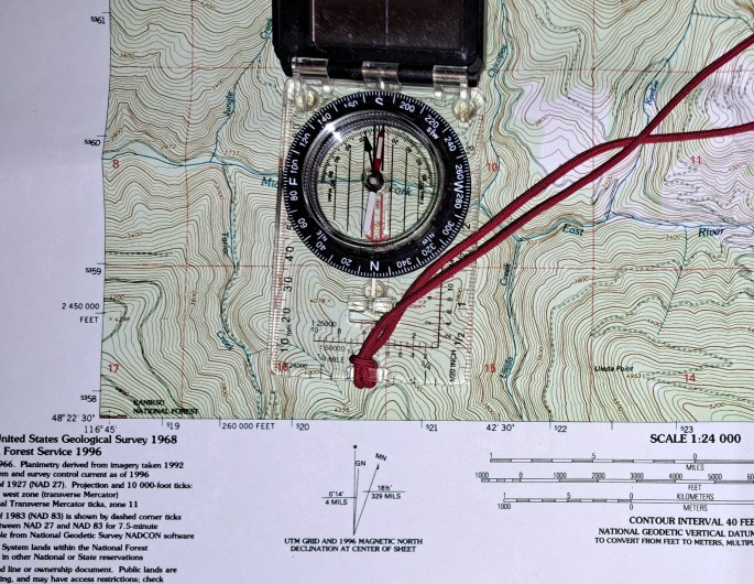
Terrain association, as the name implies, is navigating by referencing the terrain features surrounding you and locating them on your topographic map. Things such as hilltops, draws, ridges, saddles, and depressions are common ways that the ground will appear on a topographic map. Additionally you may have roads, trails, water, and man made structures which both show up on a map and are visible on the ground. If the ground has plenty of these features and you have an unobstructed view of them, then you can navigate without spending much time referencing your compass or needing to keep a pace count. Even travelling at night is quite possible if there is any amount of lunar illumination. Terrain association does seem harder for most students to grasp initially, though is much simpler once you understand the idea.
In flat and featureless terrain, everything looks the same. So instead of being able to see your location and comparing the ground and map, you will need to use detailed map work from a known point, along with a precise azimuth (compass heading) for an exact distance. If you have ever watched a naval movie, especially one with submarines, they usually have a scene where they are plotting a course on a chart (map of the water) their they are using an angle for certain distances before turning to another angle. They have the benefit of a table and coffee but otherwise its basically the same when doing it on foot. This type of work is usually has more things to keep track of (math and counting), but the principles are generally very straight forward.
There is a third type of navigating, which is strictly off of a GPS receiver. The GPS will give you a compass heading and distance to a saved point. Depending on the model and mapping software it may or may not have enough detail to show you obstacles you may run into along the way. If the terrain is rough and GPS has little detail, it could be difficult to avoid massive obstacles. These are very handy tools to have in flat featureless terrain because you are saved from math and counting. In the mountains we really only used them to pull coordinates in decimal degrees for reporting purposes as terrain association was the preferred method.
I firmly believe it worth learning of the different tools and ways to navigate, so you can pick the best tool for the job and so you have multiple options. There are people who hate GPS navigation because it is technology the military can turn off to civilians should the threat of war happen, also they run on batteries. If you are using your phone as a GPS receiver, it has a limited battery life much more than most dedicated GPS receivers. The issue with a map, is you have to have one. This is a planning issue, but sometimes you end up in a location you didn’t plan on being in, either something would come up at work and we might be going a place we hadn’t planned on, or hunted out west I have continued to drive and explore new areas I didn’t have everything on paper maps, but I had OnX maps app on my phone and it got me the information I needed. So they all have limitations and as you build experience using the various skills you can adjust to the most useful method.
The important thing is to remain calm, have an idea of where you are, and which general direction you need to walk to get back to your truck. If you think you are getting lost, sit down and once you are calm, you should be able to put together enough clues to at least know which direction will take you back to a road or some other known location.
-Joe
